


ALTA / NSPS
ALTA / NSPS
ALTA / NSPS Land Title Survey
Generally referred to as ALTA surveys, they are boundary surveys that meet the standards set forth by the American Land Title Association (ALTA) & the National Society of Professional Surveyors (NSPS) (Formerly ACSM - American Congress on Surveying and Mapping).
When purchasing commercial real estate, it is important to protect your investment, for that reason most purchasers and lenders request/require Title Insurance. However before issuing title insurance, title insurance companies require, among other items, a detailed survey showing the property in question. Based on the needs of title insurance companies, ALTA and NSPS have put together a list of minimum requirements for this survey, Minimum Standard Detail Requirements for ALTA/NSPS Land Title Surveys (Effective February 23, 2016).
Asbuilts
Asbuilts
Asbuilt Surveys / As-Constructed Surveys
An Asbuilt Survey, sometimes referred to as an As-Constructed Survey, is a Survey that documents what has been built. The surveyor obtains field measurements of vertical or horizontal dimension, or both, of the constructed improvements (foundation walls, etc.). Asbuilt Surveys are a great tool to verify that what was constructed is in the right place. They are typically performed when required by the local jurisdiction (County, Town, etc.).
Boundary Survey
Boundary Survey
BOUNDARY SURVEY
The Boundary Survey is a means of marking boundaries for sufficient definition and identification to uniquely locate each lot, parcel, or tract of land. The purpose of a boundary survey is to establish, reestablish, or describe, or all of these, the physical position and extent of the boundaries of real property. Unless otherwise directed by the party requesting the survey, sufficient monuments or reference control points which were used to determine the property lines shall be: set or recovered on the ground, to the extent feasible; and shown on a plat upon completion of the boundary survey so that the property lines can be determined or readily reestablished.
In other words, unlike a Location Survey, Boundary Surveys do provide for the accurate identification of property boundary lines and can be relied upon for the establishment or location of fences, garages, buildings, or other existing or future improvements.
Cell Tower Site Plan
Cell Tower Site Plan
CELL TOWER SITE PLAN
As the national mobile cell phone providers expand / upgrade their networks, they often need to install a new tower in a region for increased coverage. Local Jurisdictions (County's, Town's, etc.) often require plan's showing where these Towers will be located as well as other pertinent information, before said Towers can be constructed. Lavelle & Associates, Inc. has been pleased to aide in this process by providing Site Plan's & Stormwater Management Design to satisfy the requirement of Local Jurisdictions on countless projects.
Condominium Plat
Condominium Plat
CONDOMINIUM PLAT
When the declaration and bylaws are recorded, the developer shall record a condominium plat. The Condominium Plat generally consists of; the name of the condominium, a boundary survey of the property the condominium is on, diagrammatic floor plans of each building on the property which show the measured dimensions, floor area, and location of each unit in it, as well as any other applicable information.
In Maryland, A Condominium Plat or any amendment to a Condominium Plat must be certified by a Professional Land Surveyor or Property Line Surveyor authorized to practice in the State.
FAA
FAA
FAA 1A & 2C Certifications
When building tall structures, like cell towers, the Federal Aviation Administration (FAA) requires documentation of the proposed structures height as part of their "aeronautical study process." During this process, the FAA may request a "certified survey with an accuracy of either 1A (+20 ft horizontally +3ft vertically) or 2C (+50 ft horizontally +20 ft vertically)" per their Survey Accuracy standards.
FEMA
FEMA
Elevation Certificate
An Elevation Certificate is used to document your building's elevation, so that it can be compared to the estimated height of projected flood waters to help determine "your flood risk and the cost of your flood insurance."
Per FEMA, "If your home or business is in a high-risk area, your insurance agent will likely need an elevation Certificate (EC) to determine your flood insurance premium." These high risk areas, or Special Flood Hazard Areas (SFHA) are described by FEMA as "the area that will be inundated by the flood event having a 1-percent chance of being equaled or exceeded in any given year." The "1-percent" flood event is also commonly referred to as the 100-year storm.
FEMA has put together a very informative guide to help property owners determine if they need an Elevation Certificate:
Elevation Certificates: Who Needs Them and Why
For more information, visit FEMA's webpage on Elevation Certificate
Letter of Map Amendment (LOMA)
A Letter of Map Amendment (LOMA) is typically issued "because a property has been inadvertently mapped as being in the floodplain, but is actually on natural high ground above the base flood elevation."
A LOMA is an "official amendment, by letter, to an effective National Flood Insurance Program (NFIP) map." Much like how the Elevation Certificate helps to establish the building's elevation as compared to the Special Flood Hazard Area (SFHA), as outlined above, the LOMA, establishes a property's elevation in relation to the SFHA.
For more information, visit FEMA's webpage on Letter of Map Amendment (LOMA)
Location Survey
Location Survey
What is a Location Survey
Think of a Location survey as an Approximate Survey. The goal is to approximately determine the location of the property lines, buildings, and any other improvements (driveway, sidewalk, retaining walls, etc.) and how they relate to one another. All of this information is then illustrated on a drawing, referred to as a Location Drawing, or sometimes a House Location Drawing.
Location Surveys / Drawings are not "accurate"
Location Surveys / Drawings do not provide for the accurate identification of property boundary lines and should not be relied upon for the establishment or location of fences, garages, buildings, or other existing or future improvements. Again it is important to view a Location Survey as an approximation of what is actually on a property. The goal isn't to determine exactly where things are, instead the goal is to determine where things are in relation to one another. For example, does the House appear to be inside the property lines? Yes or No?
Why Location Surveys / Drawings are not "accurate"
Let's break this question down into two parts:
1. Wouldn't inaccurate Surveys mislead & confuse?
Yes, yes they would, and they do. Countless home owners assume what is shown on a Location Drawing is "accurate", and they use them to determine where to install landscaping, trees, or even fences. This can lead to disputes with adjoining neighbors who claim that they placed said tree's or fencing on their property. Ultimately a land surveyor is called to try to determine where the actual property line is by performing a Boundary Survey. The lesson here being that a Location Survey is NOT a Boundary Survey.
2. If Location Surveys mislead & confuse, then why do them?
Why do an "Approximate" Location Survey? Clearly they can lead to confusion and headaches, why not just always do a Boundary Survey? The answer to that question is two fold; what the lender requires & cost. The Location Survey is the main survey tool your Lender, Title Insurance Company, or other agent uses during refinancing or purchasing a home. It gives them a general idea of where things are, and that's typically enough for them to sign off on your loan. This is good news in that Location Surveys are much less expensive than Boundary Surveys, since they are easier to perform taking surveyors mere hours instead of days to complete. To highlight this point consider that Location Surveys will usually run in the 100's of dollars, where as Boundary Surveys will usually run in the 1,000's of dollars.
Stormwater Management
Stormwater Management
Stormwater Management in Maryland
The Stormwater Management Act of 2007 (Act) set forth new statewide standards for implementing Stormwater Management (SWM) on both Residential & Commercial projects. The Act requires that Environmental Site Design (ESD), through the use of nonstructural best management practices and other better site design techniques, be implemented to the maximum extent practicable. To aid Land Surveyors & Civil Engineers in designing these practices, the Maryland Department of the Environment (MDE) published an update to the Maryland Stormwater Design Manual, Volumes I and II (October 2000, Revised May 2009) (Manual).
Three Step Approach to ESD
1. Smart Design: Minimizing Impervious Areas & Implementing Alternative Surfaces. The less impervious areas you have, i.e. sidewalks, driveways, and buildings, the less SWM you have to provide. So minimizing impervious area, if possible, is a great way to reduce the magnitude & cost of SWM. An alternative is to incorporate SWM into your impervious surface utilizing a green roof or permeable pavement.


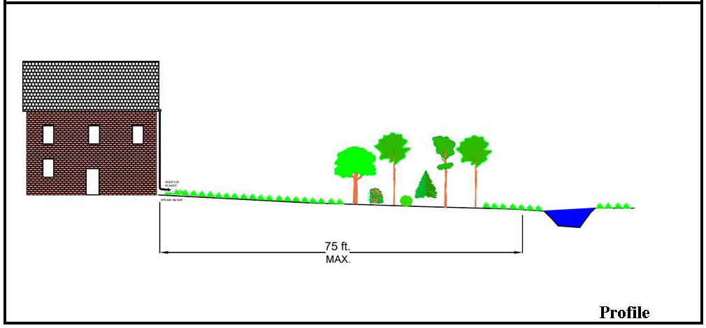
2. Nonstructural Practices: If the site has relatively flat slopes (<5%) and soils that infiltrate well, a portion of the required SWM can often be satisfied using simple and relatively inexpensive methods. These methods will allow for rain water runoff to drain over a flat grassed area and naturally infiltrate into the ground. Two great opportunities to use this credit, as the Manual refers to it, are with Rooftop Disconnect (water runoff from downspouts), and Non-rooftop Disconnect (water runoff from roads, driveways, and sidewalks).

3. Micro-Scale Practices: Often, even after utilizing Smart Design & Nonstructural Practices the SWM requirements for the project have not been satisfied. At this point the Manual requires the implementation of Structural Practices. Also referred to as Micro-Scale Practices, these devices all implement a method for holding rain water runoff, and allowing it to infiltrate directly into the ground or releasing it slowly to incerase the opportunity for downstream infiltration. These devices can include: Rain Barrels, Submerged Gravel Wetlands, Landscape Infiltration, Infiltration Berms, Dry Wells, Micro-Bioretention, Rain Gardens, Bio-swales, Wet Swales, and Enhanced Filters.


How Much SWM / ESD Do I Need?
The Manual establishes a formula which factors in the projects total disturbed area, total impervious area, and existing soil infiltration rates to calculate a volume of rain water runoff that must be stored. Furthermore, each one of the devices described above, beyond having certain rules for it's application, also has a formula to calculate how much of this volume it satisfies. Projects take one of two possible routes, either the entire required volume is stored, thus satisfying the SWM / ESD requirements for the site, or after exhausting all available methods, it is proven that ESD has been implemented to the Maximum Extent Practicable (MEP). The later implying that no other SWM / ESD devices are possible due to site conditions, such as; steep slopes, insufficient space, or soils that do not infiltrate (clay soils). Notably, aesthetics & costs are not valid justifications to support implementing ESD to the MEP, so it is very important to factor SWM into a projects budget.